Log in
All resources
Create a design
145 Free Artworks of Maps Of Bohemia
bibliothèque nationale de france
sanson maps of the circles of germany
map of the circle of austria by sanson
maps by john cary
john cary
sanson map of the german empire (17th century)
map of the german empire by louis stanislas d'arcy de la rochette
cartography
engraving
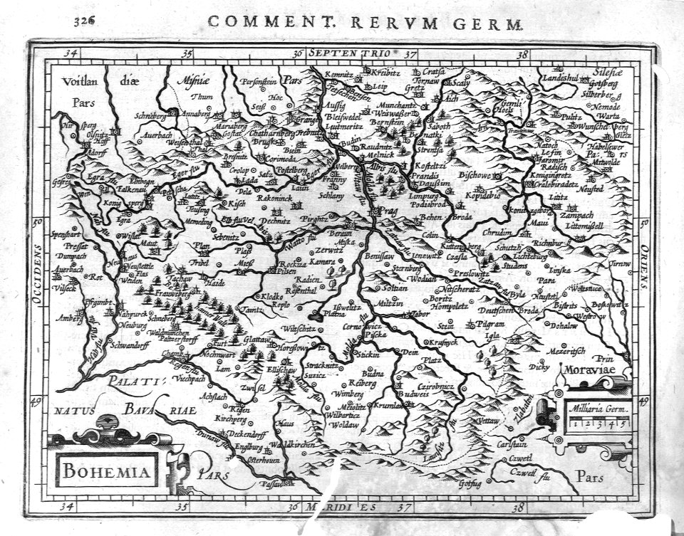
czech republic
map of the circle of austria by sanson
1680s maps of austria
map of the circle of austria by sanson
1670s maps of austria
files based of data provided by the czech office for surveying and cadastre
kačina
1801 maps of europe
maps by john cary
maps by pieter van der keere
17th-century maps of czechia
sanson map of the german empire (17th century)
sanson maps of the circles of germany
sanson map of the german empire (17th century)
sanson maps of the circles of germany
sanson map of the german empire (17th century)
sanson maps of the circles of germany
sanson map of the german empire (17th century)
sanson maps of the circles of germany
maps and topographical views by joris hoefnagel
historical images of louny
18th-century maps of bohemia
grosser deutscher atlas
maps of chomutov by braun & hogenberg
church of saint barbara (chomutov)
maps by john cary
1799 maps
maps by john cary
1801 maps
map of the circle of austria by sanson
1700s maps of austria
maps of prague by braun & hogenberg
maps of cheb by braun & hogenberg
maps of chomutov by braun & hogenberg
maps of čáslav by braun & hogenberg
maps of chomutov by braun & hogenberg
maps of čáslav by braun & hogenberg
map of the circle of austria by sanson
1670s maps of austria
maps of prague by braun & hogenberg
maps of cheb by braun & hogenberg
1794 maps of the holy roman empire
english-language maps of europe
geographia universalis (1545) in the british museum
german renaissance,northern renaissance
maps by jan eduard wagner
1890s maps of czechia
david rumsey historical map collection
old maps of the holy roman empire
l'empire d'allemagne divisé en ses dix cercles, et ces cercles en leurs principaux estats, principautés et souverainetés ecclésiastiques, laiques et villes impériales avecq le royaume de boheme et les... - btv1b53202355w
sanson maps of the circles of germany
map of the circle of austria by sanson
1700s maps of austria
cartography
maps
cartography
maps
1801 maps of germany
maps by john cary
cartography
maps
atlas sive cosmographicae (gerardus mercator, 1623)
maps of bohemia by gerardus mercator
maps of prague by joris hoefnagel
bibliothèque nationale de france
david rumsey historical map collection
1790s maps of the holy roman empire
david rumsey historical map collection
1794 maps of the holy roman empire
atlas sive cosmographicae (gerardus mercator, 1630)
maps of bohemia by gerardus mercator
sanson maps of the circles of germany
bibliothèque nationale de france
sanson maps of the circles of germany
bibliothèque nationale de france
cartography
maps
atlas ou representation du monde universel t. 2 (1633)
maps of bohemia by gerardus mercator
l'empire d'allemagne divisé en ses dix cercles en leurs principaux estats. le royaume de bohême et les provinces qui en dépendent - nouvellement reveu et corrigé par le sieur sanson... ; lud. cordier... - btv1b532023318
sanson maps of the circles of germany
geographia universalis (1545) in the british museum
german renaissance,northern renaissance
maps of polná by braun & hogenberg
bibliothèque nationale de france
carte du royaume de bohême, dicisé en xv cercles, avec le comté de glatz et le territoire d'egra. réduite d'après la carte de muller, et revue d'après celles de maurice vogt, d'hofman et de j. de ram... - btv1b532026015
johannes de ram
carte du royaume de bohême, dicisé en xv cercles, avec le comté de glatz et le territoire d'egra. réduite d'après la carte de muller, et revue d'après celles de maurice vogt, d'hofman et de j. de ram... - btv1b532026015
johannes de ram
17th-century prints in the rijksmuseum amsterdam
maps of polná by braun & hogenberg
101 - 145 of 145
/ 2


![Czaslavium vulgo Czasla Bohemiae civitas; Commoda vulgo Comethau Bohemiae civitas / Communicavit G. Houfnaglius depictum a filio A[nn]o 1617, 1635](https://cdn.creazilla.com/illustrations/10000484269/czaslavium-vulgo-czasla-bohemiae-civitas-commoda-vulgo-comethau-bohemiae-civitas-communicavit-g-houfnaglius-depictum-a-filio-anno-1617-1635-sm.webp)
![Czaslavium vulgo Czasla Bohemiae civitas; Commoda vulgo Comethau Bohemiae civitas / Communicavit G. Houfnaglius depictum a filio A[nn]o 1617, 1635](https://cdn.creazilla.com/illustrations/10000386904/czaslavium-vulgo-czasla-bohemiae-civitas-commoda-vulgo-comethau-bohemiae-civitas-communicavit-g-houfnaglius-depictum-a-filio-a-nn-o-1617-1635-md.jpg)


![Gerardi Mercatoris and I. Hondii Atlas or Representation of the Universal World, and of the Parts of It, Made in Tables and Very Ample Descriptions. [t. 2].](https://cdn.creazilla.com/illustrations/10000238363/gerardi-mercatoris-and-i-hondii-atlas-or-representation-of-the-universal-world-and-of-the-parts-of-it-made-in-tables-and-very-ample-descriptions-t-2-sm.webp)


![Polna vulgo Polm insign. Bohemiae civitas regnum a Moravia dividens / Communicavit Georg[ius] Houfnaglius depictum a filio A[nn]o 1617, 1635](https://cdn.creazilla.com/illustrations/10001289479/polna-vulgo-polm-insign-bohemiae-civitas-regnum-a-moravia-dividens-communicavit-georgius-houfnaglius-depictum-a-filio-anno-1617-1635-md.jpg)


